INDI Library v2.0.7 is Released (01 Apr 2024)
Bi-monthly release with minor bug fixes and improvements
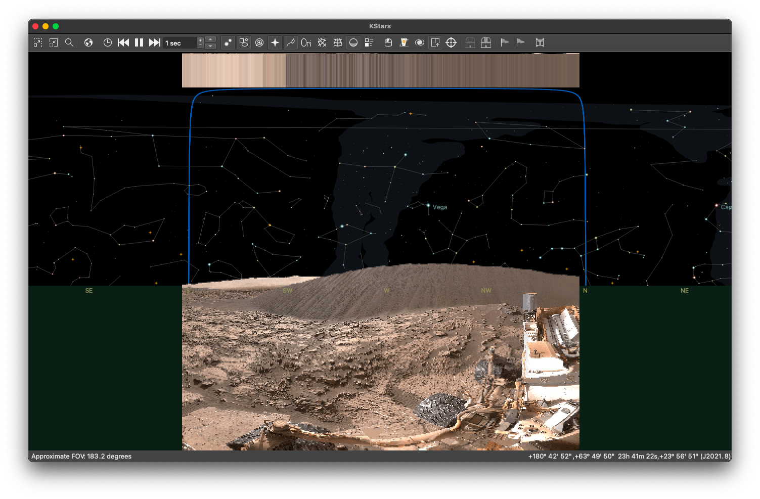
New Feature: Terrain backgrounds
- Remco Hekker
-
- Offline
- New Member
-


- Posts: 18
- Thank you received: 1
Replied by Remco Hekker on topic New Feature: Terrain backgrounds
As someone who is pretty new to astronomy, this feature really helps fill in the gaps between looking at sky charts and looking up.
Thank you!
Attachments:
Please Log in or Create an account to join the conversation.
- Hy Murveit
-
 Topic Author
- Away
- Administrator
-

- Posts: 1221
- Thank you received: 565
Replied by Hy Murveit on topic New Feature: Terrain backgrounds
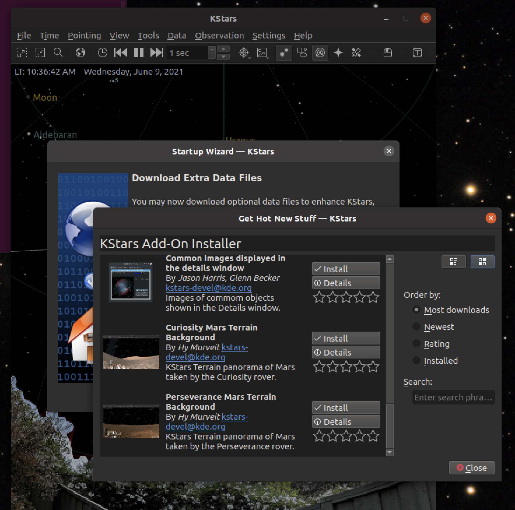
How do we get these two images into kstars…?
Sorry, I'm a bit out-of-context. Do you mean the two Mars sample terrain images I prepared?
If so, they are available in the "download extra data" part of the KStars "startup wizard", which can be found in the KStars "Settings" menu.
Attachments:
Please Log in or Create an account to join the conversation.
Replied by AstroNerd on topic New Feature: Terrain backgrounds
No the two images posted that are a much smaller file size that have been posted earlier, by Andrew, as the two you mention are too big in file size and cause bad lag when using over VNC with a 2k monitor….I can’t use the HIPS overlay either as it just slows it all down to a crawl…..I just wish there ws a better VNC out there that would work well with 2k and 4k monitors…..

Please Log in or Create an account to join the conversation.
- Hy Murveit
-
Topic Author
- Away
- Administrator
-
- Posts: 1221
- Thank you received: 565
Replied by Hy Murveit on topic New Feature: Terrain backgrounds
Please Log in or Create an account to join the conversation.
Replied by AstroNerd on topic New Feature: Terrain backgrounds
yes I get that, so back to my original question, if I have an image file I want to add to Kstars, how do I add it manually…..????
Please Log in or Create an account to join the conversation.
- Hy Murveit
-
Topic Author
- Away
- Administrator
-
- Posts: 1221
- Thank you received: 565
Replied by Hy Murveit on topic New Feature: Terrain backgrounds
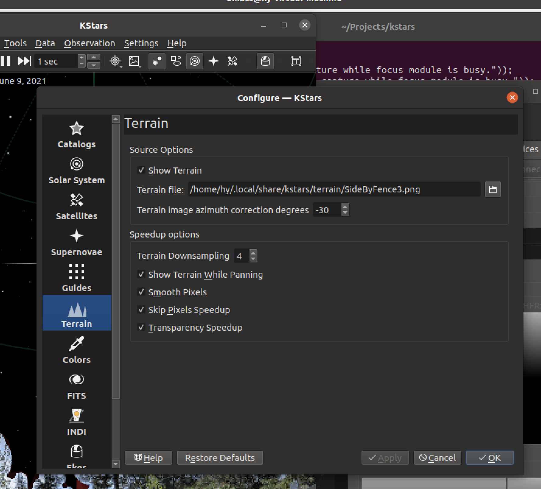
Select the file you want (defaults to the default directory for terrain) and set the azimuth correction to match the image and the sky (doesn't matter for Mars, but matters for your own surroundings) and check "Show Terrain" and click on "Apply".
If you have your own file, it's good, but not required, to put it in the same directory as the terrain settings file-chooser defaults to.
Attachments:
Please Log in or Create an account to join the conversation.
- jiberjaber
-

- Offline
- Senior Member
-

- Posts: 67
- Thank you received: 3
Replied by jiberjaber on topic New Feature: Terrain backgrounds
")
Please Log in or Create an account to join the conversation.
- Hy Murveit
-
Topic Author
- Away
- Administrator
-
- Posts: 1221
- Thank you received: 565
Replied by Hy Murveit on topic New Feature: Terrain backgrounds
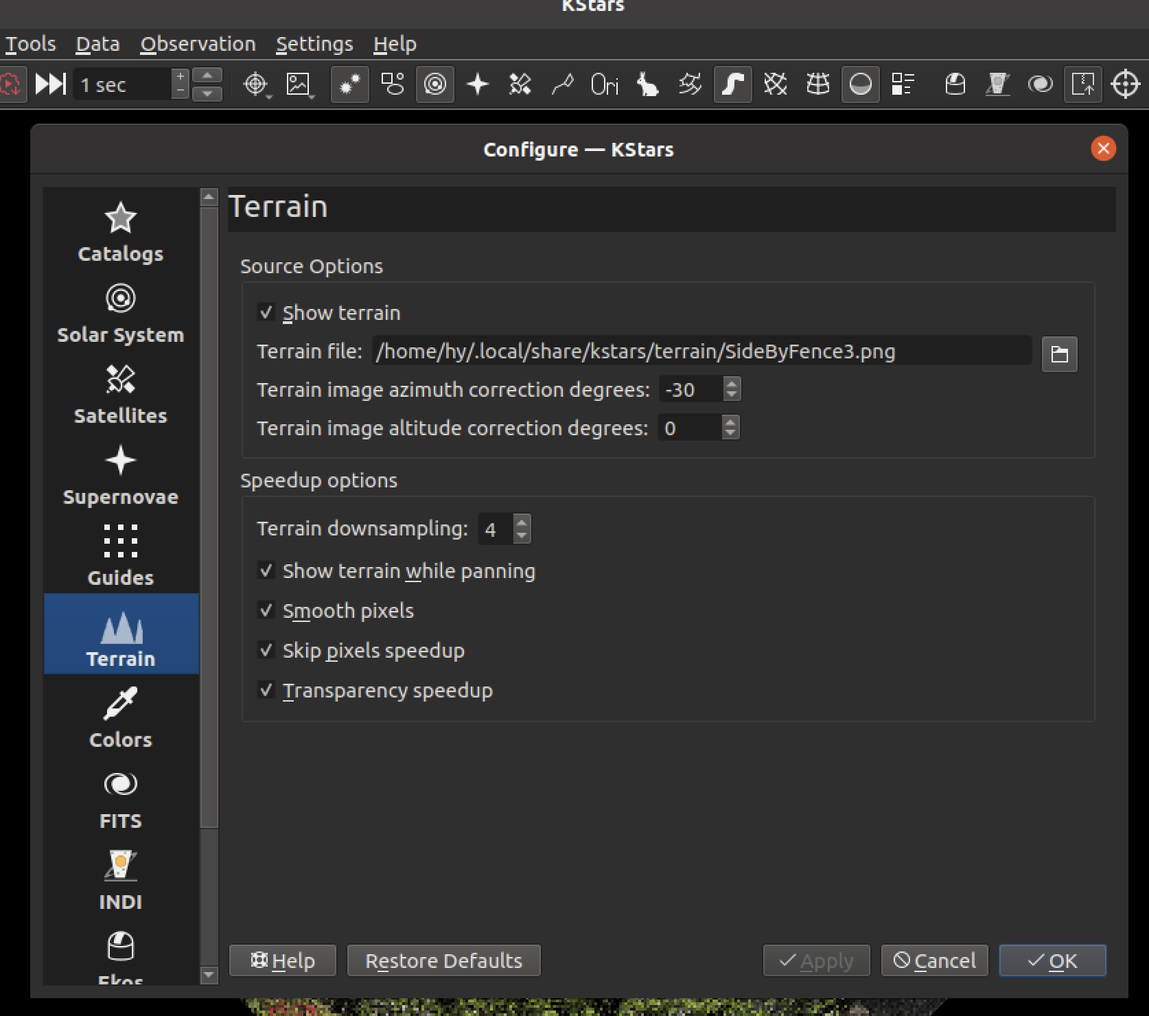
The bottom line in the "Source Options" section, "Terrain Image Altitude Correction Degrees" allows you to enter the altitude correction.
If you enter a positive number and hit apply, it will raise your terrain image by that many degrees in altitude (yes, I know, thus causing a little, hopefully harmless, transparent hole below us, at -90-degrees altitude). A negative number similarly lowers the terrain image. This setting has no effect on any artificial horizon lines you may have entered. It is purely visual.
Hope this helps,
Hy
Attachments:
Please Log in or Create an account to join the conversation.
- jiberjaber
-
- Offline
- Senior Member
-
- Posts: 67
- Thank you received: 3
Replied by jiberjaber on topic New Feature: Terrain backgrounds
Please Log in or Create an account to join the conversation.
- Gonzothegreat
-

- Offline
- Moderator
-

- Posts: 2255
- Thank you received: 223
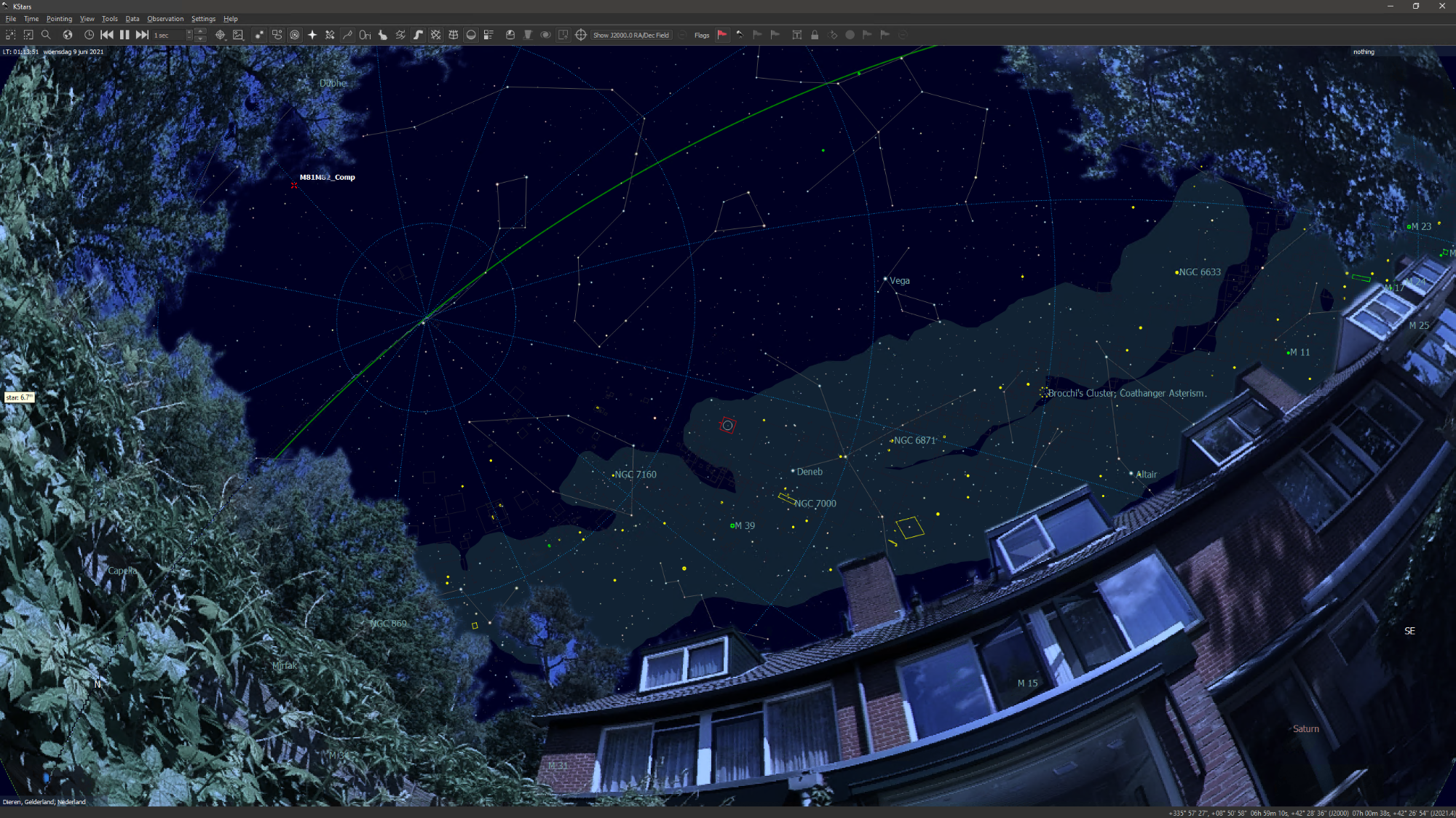
Replied by Gonzothegreat on topic New Feature: Terrain backgrounds
Attachments:
Please Log in or Create an account to join the conversation.
- Hy Murveit
-
Topic Author
- Away
- Administrator
-
- Posts: 1221
- Thank you received: 565
Replied by Hy Murveit on topic New Feature: Terrain backgrounds
Hy
Please Log in or Create an account to join the conversation.
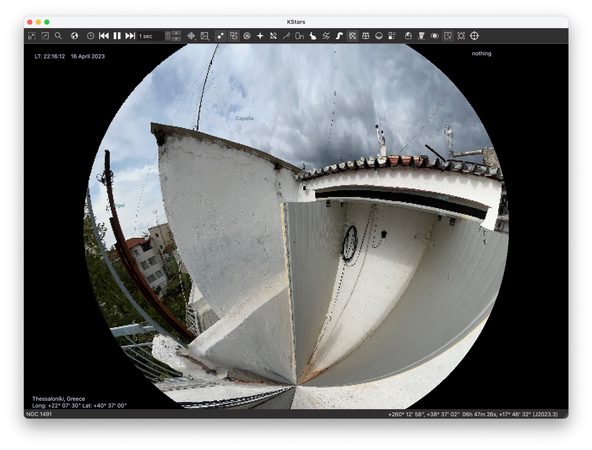
Replied by Euripides on topic New Feature: Terrain backgrounds
Now that Google decided to shut down the ability to capture 360 photos with the street view app, is there a way to load as a terrain at least a panorama photo?
The photo loads up, but due to projections, it is not right, or maybe the Gnomonic is quite close.
Any ideas?
PS. No dedicated 360 camera available
Please Log in or Create an account to join the conversation.