INDI Library v2.0.7 is Released (01 Apr 2024)
Bi-monthly release with minor bug fixes and improvements
Altitude vs. Time Tool -- compass point -- obstructions
Altitude vs. Time Tool -- compass point -- obstructions was created by Heiko
I have to make heavy use of the Altitude vs. Time Tool.
The reason is that I take my pictures from a balcony.
The house and my neighbours' houses are obstructions to the north. Whereas some tall trees are obstructions to the south.
It would be easy for me to measure the compass points of the obstructions and to find out (by trial and error) the top of the obstructions.
It would be helpful if the user could read the compass point in the AvsT Tool.
And why not improve the tool by creating an option that gives the user the chance to add the surrounding obstructions to the tool so that the AvsT Tool could show them as rectangles rising from the ground.
What do you think?
GNU / Linux
Git
KDE neon
KStars | EKOS | INDI
and some cheap hardware
Please Log in or Create an account to join the conversation.
Replied by Heiko on topic Altitude vs. Time Tool -- compass point -- obstructions
The obstacles around the circle and the path of the object marked on the sphere.
If you hover with the mouse pointer over the path of the object time and altitude could be displayed.
And the user should be able to set the obstacles;
for example by entering two compass points for the width
and by entering the altitude of the top of the obstacle in degrees
in a table list
for as many obstacles as the user wishes to add.
Or some kind of handdrawing?
GNU / Linux
Git
KDE neon
KStars | EKOS | INDI
and some cheap hardware
Please Log in or Create an account to join the conversation.
Replied by Andrew on topic Altitude vs. Time Tool -- compass point -- obstructions
Please Log in or Create an account to join the conversation.
Replied by Heiko on topic Altitude vs. Time Tool -- compass point -- obstructions
thank you for pointing me to the Artificial Horizon Manager. This is exactly the kind of table list I had in mind.
But I used it and recognized that the created obstacle does not show up in the AvsT tool.
The obstacles are only visible on the skymap. I tried to plan a session with the skymap. But it is not intuitive. I can go forward in time, but I cannot slew the mount to this position of the object in the future. I would like to do this in order to have a look if the scope is pointing to the wall, roof, tree or free part of the sky. Maybe this could be changed?
GNU / Linux
Git
KDE neon
KStars | EKOS | INDI
and some cheap hardware
Please Log in or Create an account to join the conversation.
- Scott Denning
-
- Offline
- Elite Member
-

- Posts: 300
- Thank you received: 57
Replied by Scott Denning on topic Altitude vs. Time Tool -- compass point -- obstructions
This would be a huge improvement for all who image from complex landscapes, either urban or rural.
Please Log in or Create an account to join the conversation.
Replied by Andrew on topic Altitude vs. Time Tool -- compass point -- obstructions
Please Log in or Create an account to join the conversation.
Replied by Heiko on topic Altitude vs. Time Tool -- compass point -- obstructions
ok the skyview could be useful for planning a session. But one important part of the puzzle is missing - or not?
On the skyview I can show the Celestial equator and the Celestial meridian. I can find a target and the bulls eye marks the target. I can show the artifical horizon. But, the missing part is the path of my target on the sphere. This would be really useful information (together with time and altitude for any given point on the path)!
GNU / Linux
Git
KDE neon
KStars | EKOS | INDI
and some cheap hardware
Please Log in or Create an account to join the conversation.
Replied by Andrew on topic Altitude vs. Time Tool -- compass point -- obstructions
Please Log in or Create an account to join the conversation.
Replied by Heiko on topic Altitude vs. Time Tool -- compass point -- obstructions
On the other hand, if the Celestial equator can be plotted it must be possible to plot another circle at the angle of declination above or under the celestial equator which describes the target's altitude.
GNU / Linux
Git
KDE neon
KStars | EKOS | INDI
and some cheap hardware
Please Log in or Create an account to join the conversation.
Replied by Heiko on topic Altitude vs. Time Tool -- compass point -- obstructions
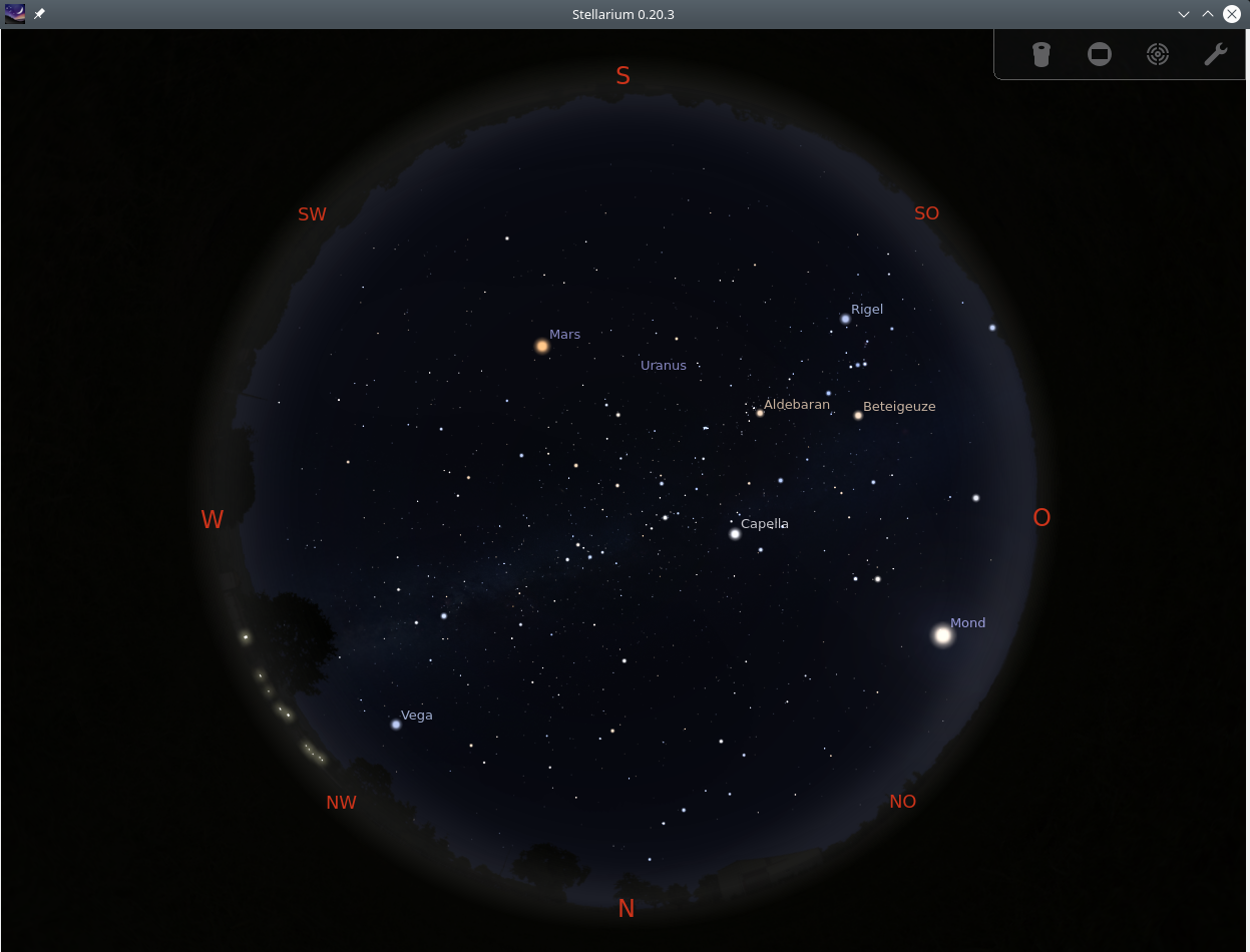
This does not look right. The obstacles - they appear to be defying gravity.
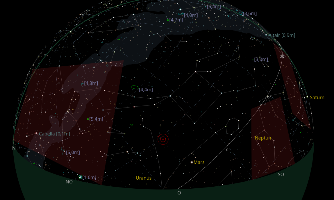

On the first image the right most of the three is in the sky.
On the second image it is the left most.
I moved the view to the left.
GNU / Linux
Git
KDE neon
KStars | EKOS | INDI
and some cheap hardware
Please Log in or Create an account to join the conversation.
Replied by Jim on topic Altitude vs. Time Tool -- compass point -- obstructions
Please Log in or Create an account to join the conversation.
Replied by Heiko on topic Altitude vs. Time Tool -- compass point -- obstructions
This is the ortographic projection which resembles a marble.
And - being a marble the left most obstruction should become invisible.
Instead it was flipping over to a different part of the night sky. On the second picture it covers Pegasus.
I will not abandon all hope that this will be improved
")
GNU / Linux
Git
KDE neon
KStars | EKOS | INDI
and some cheap hardware
Please Log in or Create an account to join the conversation.